




 Lionel
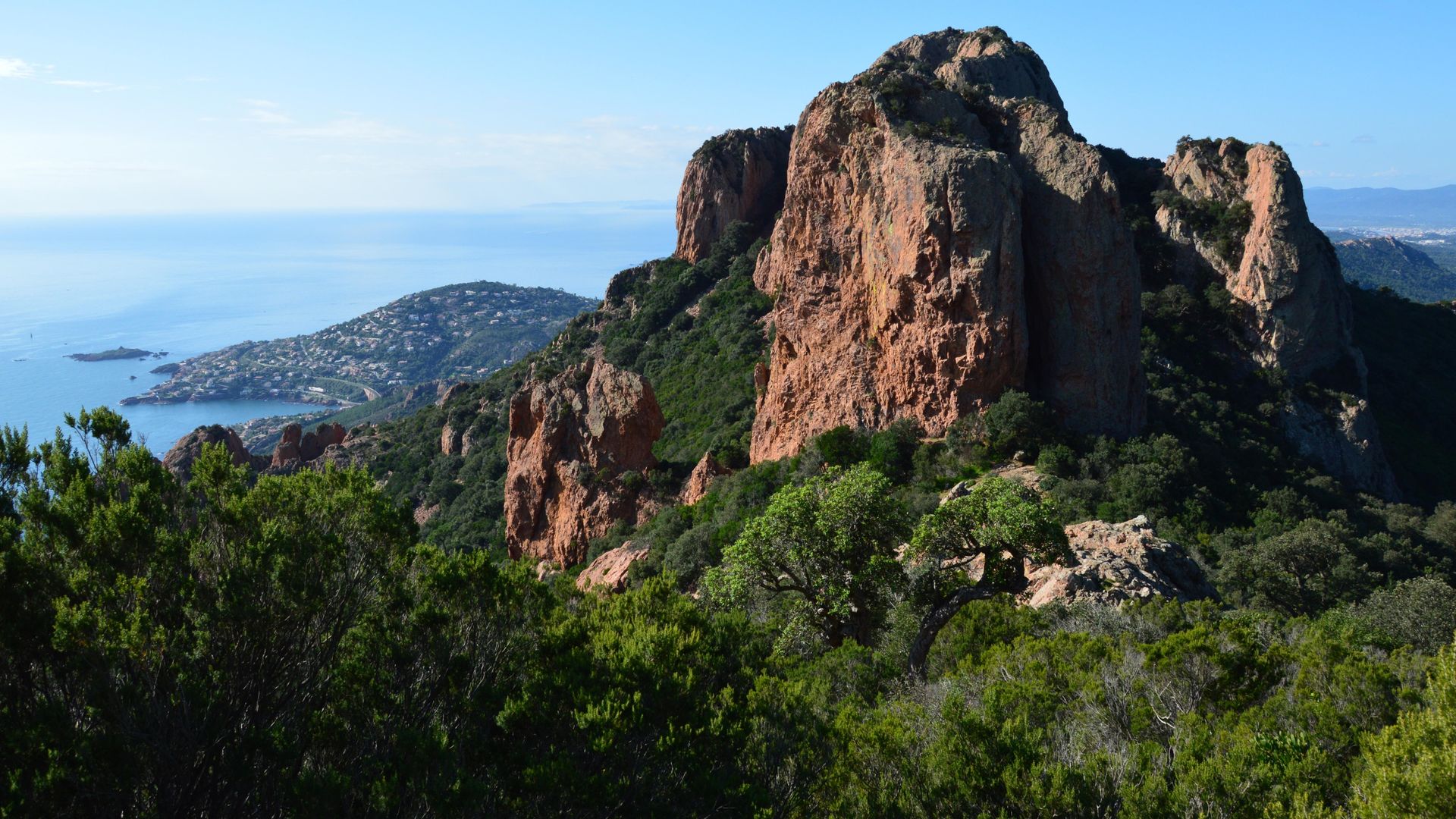
The Estérel is the only massif on the Côte d’Azur where you can step off a train, walk for ten minutes and swim in a calanque, a rocky inlet, of red stone. The secret is precisely to leave the car behind: the TER regional train line that hugs the Corniche d’Or stops at tiny stations at the foot of the coves and trails. You do, however, need to know the rules of the massif, which change every day in summer.
Updated October 2026
At a glance
- Where: between Fréjus and Théoule-sur-Mer, straddling the Var and Alpes-Maritimes départements: Saint-Raphaël, Agay, Anthéor, Le Trayas, Théoule and the massif itself.
- When: October to June for hiking; June and September for the coves.
- Getting there: TER trains between Saint-Raphaël and Mandelieu-la-Napoule, stopping at Le Dramont, Agay, Anthéor-Cap-Roux and Le Trayas.
- Who it’s for: hikers, snorkellers, families looking for small beaches, photographers.
- Good to know: the massif is closed at night all year round, and access is regulated day by day during the wildfire season.
Why the Estérel is like nowhere else
The Estérel is volcanic in origin. Its signature rock, rhyolite, gives it the red that stands out so sharply against the dark green of the pines and the blue of the sea. The landscape is protected, and the Estérel state forest alone covers more than 6,000 hectares within the Natura 2000 network. Part of it is a strict biological reserve, where nature evolves without human intervention.
The massif is small but deeply indented. Its summits barely top 600 metres and drop almost straight into the sea. The result: in a single day you can climb to a viewpoint, come back down to a calanque and finish at the market in Saint-Raphaël. Provided, that is, you respect a fragile massif that has already burned a great deal.
Rules for accessing the massif
This is the one point never to overlook. The Estérel is one of the most closely monitored massifs in the region.
All year round
- Night closure: according to the town and tourist office of Saint-Raphaël, the massif is closed between 9pm and 6am, all year round.
- Fires and cigarettes: banned in the forest. No barbecues, no wild camping.
- Forest tracks: some forest roads are open to traffic, others are not. Respect the barriers and never park in front of them: they are there for the fire brigade.
In summer, on the Var side (Fréjus, Saint-Raphaël, Agay, Anthéor)
From mid-June to the end of September, the Var prefecture (the département’s state authority) publishes a daily forest-access map, updated at around 6pm for the following day. The Estérel appears on it as a massif in its own right. The levels are:
- Green: access permitted.
- Yellow: access permitted, take care.
- Orange: access advised against.
- Red: access banned, except in designated public reception areas within the forest.
- Black: access banned in all massifs.
The map is on risque-prevention-incendie.fr (Var section), and it is the one that counts. Full-closure days are not rare: on 18 July 2026, for example, every massif in the Var, the Estérel included, was closed because of extreme risk.
In summer, on the Alpes-Maritimes side (Théoule-sur-Mer)
The eastern part of the massif falls under a different system, that of the Alpes-Maritimes. From roughly mid-June to the end of September, a risk level is published for each commune: green (access permitted), yellow and orange (access advised against), red (access banned). All year round, driving and parking on the forest tracks are banned there, except for authorised users. Check risque-prevention-incendie.fr, Alpes-Maritimes section.
Insider tip: look at the map the evening before, not on the morning itself. If the Estérel turns red, switch your day to the coastal path and the coves of the Corniche, which remain the best plan B. If you see a fire starting, call 18 or 112.
The coastal train: how to do it all without a car
The Les Arcs-Draguignan – Saint-Raphaël – Cannes TER line follows the Corniche d’Or as close to the water as it gets. Between Saint-Raphaël and Mandelieu-la-Napoule, it stops at little stations set at the foot of the coves. In summer, when the roadside car parks are full from early morning, it is by far the simplest way to reach the calanques.
- Saint-Raphaël-Valescure: the old town, the harbour and Le Veillat beach.
- Boulouris-sur-Mer: the start of a stretch of coastal path towards the Fournas and Homme Mort beaches, then Le Dramont.
- Le Dramont: the Plage du Débarquement (Landing Beach), Cap Dramont and its signal station, and the little port of Le Poussaï facing the Île d’Or.
- Agay: the bay, its beaches and the start of the roads into the massif.
- Anthéor-Cap-Roux: the viaduct, Anthéor beach and the coves towards the Île des Vieilles.
- Le Trayas: the Maupas calanque a few minutes’ walk away, and the start of the route up the Pic d’Aurelle.
- Mandelieu-la-Napoule: the Raguette and Château beaches, a few minutes from the station.
Tickets are valid for a single journey, so plan for both the outward and return legs. Trains are not frequent, especially at weekends. Check the day’s timetable on the Région Sud TER website or on SNCF Connect before you go.
Insider tip: walk the coastal path one way and come back by train. Set off on foot from Saint-Raphaël or Boulouris, walk to Le Dramont or Agay, and pick up the TER. You avoid retracing the same stretch and have no car to collect.
The Saint-Raphaël coastal path
Waymarked in yellow, it links the Santa Lucia marina in Saint-Raphaël with Camp Long beach at Le Dramont. The tourist office describes it as follows:
- Distance: 11 km one way.
- Time: about 4 hours 30.
- Ascent: little overall, but the ground is rocky and the route is graded difficult.
- Stages: La Péguière, the port of Boulouris, Aiguebonne beach, the Plage du Débarquement, the Pointe de Pierre Blave, the Cap Dramont signal station and the port of Le Poussaï.
- In sections: you can walk just part of it, for example from Santa Lucia to La Péguière.
- Works: during winter 2026-2027, the port of Le Poussaï cannot be reached by the usual path; a waymarked diversion of about 650 metres runs along Boulevard du Sémaphore.
- Getting back: TER (Saint-Raphaël, Boulouris, Le Dramont and Agay stations) or the buses along the RN98 coast road.
The rocks along the shore can be slippery. Walking shoes are essential, even for a short stretch.
The coves of the Corniche d’Or
The Corniche d’Or road between Saint-Raphaël and Cannes opened in 1903 under the aegis of the Touring Club de France. Long before it, the Roman Via Aurelia already ran along this coast. Below the road, a dozen coves and small beaches are tucked in at the foot of the red rock.
Le Dramont and the Plage du Débarquement
A memorial here commemorates the Allied landings of 15 August 1944. The beach is made of bluish porphyry pebbles that give the water its clarity; water shoes are a good idea. Opposite, the Île d’Or and its tower make one of the most photographed views in the Estérel. On site: kayak hire and lifeguards in season. Note that dogs are banned from 15 June to 15 September, even on a lead.
Anthéor and the Île des Vieilles
At the foot of the Anthéor viaduct, the beach is the base for kayaking or paddleboarding out to the Île des Vieilles and the Saint-Barthélemy calanque. The Île des Vieilles cove, which you can reach by road, is renowned for snorkelling.
Le Trayas and its calanques
Le Trayas is a hamlet of steep lanes clinging to the cliff. About five minutes’ walk from the station, the Maupas calanque is an excellent snorkelling spot. The coves of Le Trayas, L’Aurelle and Le Maubois link up in roughly half an hour’s walk. A viewpoint above the hamlet offers one of the finest panoramas on the Corniche.
Théoule-sur-Mer and the Pointe de l’Aiguille
On the Alpes-Maritimes side, Théoule protects its coastline within the Estérel-Théoule departmental marine park, owned by the Conservatoire du Littoral, France’s coastal protection agency. At the Pointe de l’Aiguille, an underwater trail is open to all from mid-June to mid-September; waterproof booklets are available from the tourist office. The three Aiguille coves are about twenty minutes’ walk away, in good shoes. The easiest to reach is the one at the point, via steps; another, near the Gardanne caves and hard to get to, is used mainly by naturists.
- La Petite Fontaine beach: sand and cliffs, facing east, so it stays cooler during the hottest hours.
- Le Château beach: in the centre of the village, the most practical with a family.
- Rule to know: sea-urchin fishing is banned here from 16 April to 31 October.
More calanques and discreet beaches along the whole coast are gathered in our guide to the secret beaches of the Côte d’Azur.
The massif’s great walks
Cap Roux and Saint Honorat’s cave
This is the most rewarding walk for a first visit. From the Sainte-Baume car park (follow “Massif de l’Estérel” at the Agay roundabout, then signs for the Col Notre-Dame), Saint-Raphaël’s tourist office gives a loop of 4.3 km and around 2 hours. You pass a chapel tucked into the rock, a drinking-water fountain, then the Col du Saint-Pilon. At the summit of Cap Roux, at 453 metres, a viewpoint indicator takes in the coast from Cannes to Cap Camarat. As an option, allow about 45 minutes there and back for the Sainte-Baume cave, where the hermit Saint Honorat lived.
The Pic de l’Ours
From the Col Notre-Dame car park, at the dead end of a road some twelve kilometres from the seafront, the path passes below the Dent de l’Ours and climbs to the antenna on the summit, at almost 500 metres. The view covers the whole massif, the bays of Cannes and Saint-Raphaël, the Lérins Islands and, on a clear day, the Mercantour mountains. The descent is steep and stony; a tarmac road offers a gentler alternative.
Mont Vinaigre, the roof of the Estérel
The massif’s highest point, at 614 metres, Mont Vinaigre is climbed from the Fréjus side, via the Route des Cols, the Malpey area or the Lac de l’Avellan. There are several routes, from half a day to a full day. On a clear day, the panorama stretches from the Mercantour to Saint-Tropez.
The Pic d’Aurelle from Le Trayas
A demanding hike, reachable from Le Trayas station: the Estérel Côte d’Azur tourist office estimates it at about 2 hours 30 and 345 metres of ascent, with a 360-degree panorama at the top. It is not suitable for young children or beginner walkers.
- Kit: walking shoes, plenty of water and sun protection. There is no shade on the ridges.
- Waymarking: GR long-distance trails in red and white, longer loops in yellow, shorter loops in blue.
- Timing: be back before the massif’s night closure.
Insider tip: the best seasons for the ridges are autumn and late winter. The light is crisper, the view reaches the snow-capped Alps, and you don’t depend on the summer access map. In summer, set off as soon as the massif opens and come down before the hottest hours.
For more quiet trails, see our walks and hikes off the beaten track.
Towns and heritage
Fréjus, the Roman town
Fréjus is one of the oldest towns on the coast, founded as Forum Julii. It still has a Roman amphitheatre and theatre, and an archaeological museum displaying amphorae, mosaics and a double-faced bust of Bacchus and Pan. Also worth seeing is the Notre-Dame-de-Jérusalem chapel, whose architecture and decoration were designed by Jean Cocteau in 1963, the year he died. The town offers a pass for visiting these sites one after another.
Saint-Raphaël’s old town
Behind the Belle Époque seafront, the old quarter hides the San Rafeu church and its tower: 129 steps up for a view over the whole bay. The neighbouring archaeology museum and the Notre-Dame-de-la-Victoire basilica, near the Vieux-Port, round off the walk.
Agay, Le Trayas, Théoule
These aren’t hilltop villages but small-scale resorts that grew up with the road and the railway. Agay opens onto its sheltered bay; Le Trayas clings to the cliff; Théoule keeps a small harbour and its château on the beach. Inland, Les Adrets-de-l’Estérel gives a sense of life at the heart of the massif.
For more characterful villages, see our selection of the most beautiful villages of France on the Côte d’Azur.
Food and markets
The Estérel’s markets are mainly on the Var side. Here are the main ones, based on the tourist office listings. Times can change, so check before you go.
- Saint-Raphaël, Victor-Hugo market: Tuesday to Sunday mornings, in the town centre. Food, flowers and local producers, plus clothing on Thursdays.
- Saint-Raphaël, fish market: every morning.
- Fréjus, Provençal market: Wednesday and Saturday mornings, Place Formigé, all year round (cancelled in bad weather).
- Fréjus, other markets: Thursday mornings at Les Arènes and Port-Fréjus, Sunday mornings at Fréjus-Plage.
- Agay: Wednesday mornings, in the car park of the watersports centre, all year round.
- Les Adrets-de-l’Estérel: Wednesday and Sunday mornings.
- Théoule-sur-Mer: ask the Théoule tourist office for market days.
Worth tasting: the catch of the day bought at the harbour in Saint-Raphaël, vegetables from the market gardeners of the Argens plain, and honey from the massif. For a picnic in a cove, a morning stop at the Victor-Hugo market followed by the train to Le Trayas makes for a perfect day.
To understand local traditions better, read our feature on the culture and traditions of the Côte d’Azur.
When to come (and why the off-season is ideal)
- October–November: the best season for hiking. No summer restrictions, a sea that’s still mild in the first few weeks and warm colours on the red rock.
- December–March: the massif is quiet and the views carry a long way. The days are short, so start early to be back before dark.
- April–June: rockroses and heather in flower, crystal-clear water. From mid-June the access map comes into force; the underwater trail at the Pointe de l’Aiguille also opens around then.
- July–August: favour the sea, the coastal path and the train. For the massif, check the map every evening and go out early.
- September: warm sea and thinning crowds, but access restrictions are still possible until the end of the month.
Getting around and parking
- By train: the best option in summer for the Corniche (see above).
- By car: the Corniche d’Or is a narrow, winding road with few roadside spaces. In summer, the spots near the coves are taken early in the morning.
- Into the massif: from the Agay roundabout, follow “Massif de l’Estérel” towards the Sainte-Baume and Col Notre-Dame car parks. On the Fréjus side, access is via the Malpey area and the Route des Cols, depending on which roads are open.
- By bus: buses serve the RN98 between Saint-Raphaël and Agay, useful for getting back from a section of the coastal path.
- Golden rule: never park in front of a forest barrier or on a track. The emergency services must be able to get through at all times.
Where to stay
To make the most of the massif early in the morning, stay in Agay, Anthéor or Le Trayas, as close as possible to the trails and stations, or choose Saint-Raphaël and Fréjus for their markets and wider choice; the campsites around the bay of Agay and the holiday residences of Théoule make good bases for a car-free stay.
Our hand-picked campsites in the area, on Yes I Camp: La Plage du Dramont (Agay), La Baume – La Palmeraie (Fréjus), Cœur de l’Estérel – Oasis Village (Fréjus) and Leï Suves (Roquebrune-sur-Argens).
See also all our campsites in Provence-Alpes-Côte d’Azur on Yes I Camp.
FAQ
Is the Estérel massif open in summer?
It depends on the day. From mid-June to the end of September, the Var prefecture publishes an access map every evening at around 6pm for the following day. At red level, access is banned outside the designated public reception areas; at black level, all massifs are closed. For Théoule, check the Alpes-Maritimes system. Both maps are on risque-prevention-incendie.fr.
Can you go into the Estérel in the evening?
No. According to the town and tourist office of Saint-Raphaël, the massif is closed from 9pm to 6am, all year round. Plan your hikes so you are back down before closing time.
How do you reach the Corniche d’Or calanques without a car?
Take the TER between Saint-Raphaël and Mandelieu-la-Napoule. Le Dramont, Agay, Anthéor-Cap-Roux and Le Trayas stations are all a few minutes’ walk from the coves. Do check the timetable, as trains are infrequent.
Which hike is best for a first visit to the Estérel?
The Cap Roux loop from the Sainte-Baume car park: about 4.3 km and 2 hours, with a chapel in the rock, a spring and a viewpoint indicator at 453 metres. For something easier, pick a section of the Saint-Raphaël coastal path.
Where can you go snorkelling in the Estérel?
The Maupas calanque at Le Trayas, the Île des Vieilles cove at Anthéor and the underwater trail at the Pointe de l’Aiguille in Théoule, open from mid-June to mid-September. Take care in rough seas and respect the swimming zones.
Further reading
- Cannes, the Lérins Islands and Grasse beyond the glitz
- The secret Gulf of Saint-Tropez: an insider’s guide
- Bormes, Le Lavandou and the Maures: an insider’s guide
- The Calanques and Cassis, the insider’s way
- 15 off-the-beaten-track hikes on the French Riviera
- Natural wonders of the French Riviera
- The Mimosa Route from Bormes to Grasse in 3 days