




 Lionel
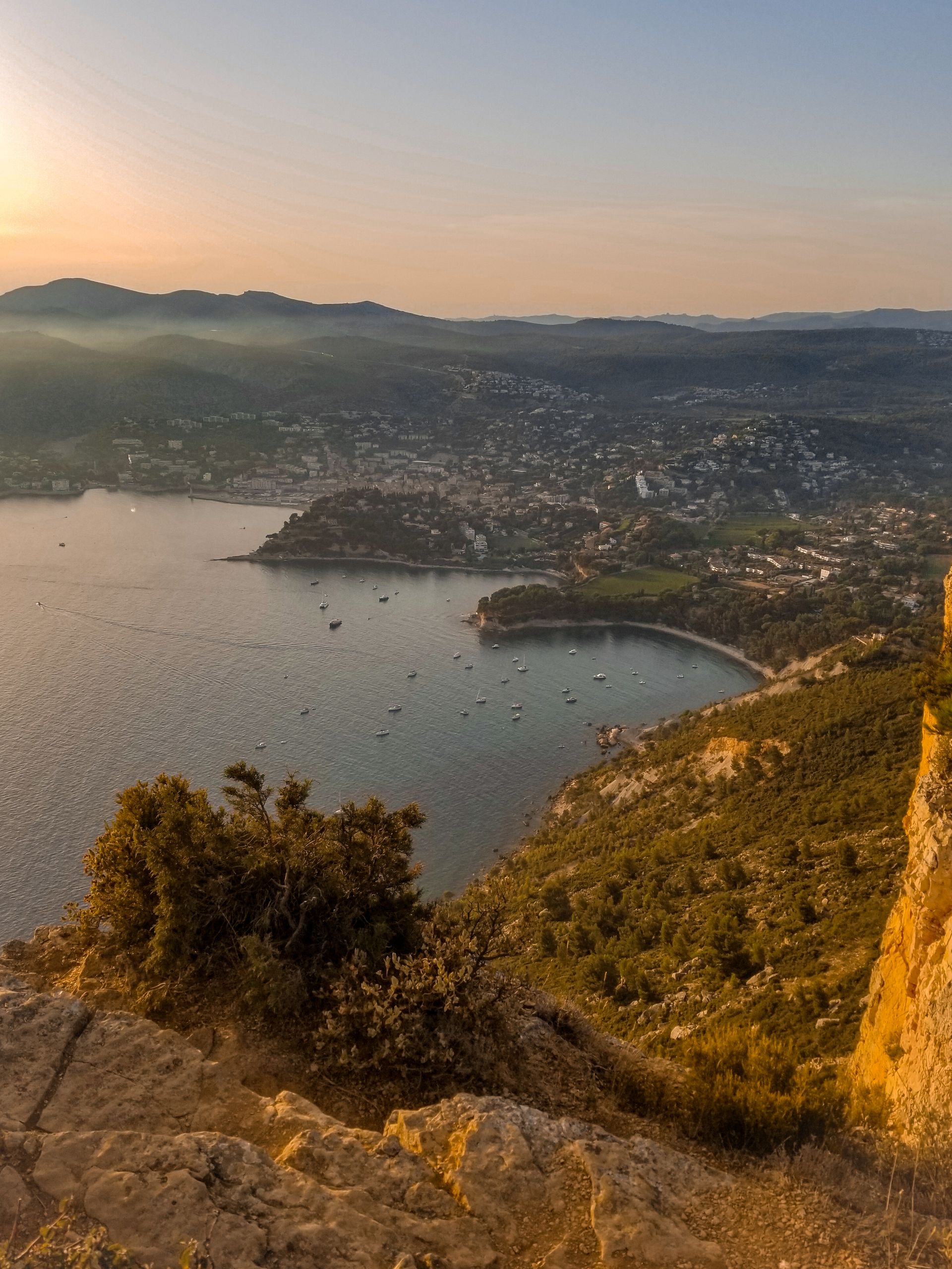
The Calanques have to be earned, and in summer they are booked, closed and regulated. The real secret comes down to three habits: book Sugiton three days ahead from 9am, check the forest-access map every evening at around 6pm, and leave the car well away from the coves. With those three keys, you’ll see southern Marseille, Cassis and La Ciotat the way the regulars do.
Updated October 2026
At a glance
- Where: from Callelongue (Marseille’s 8th arrondissement) to La Ciotat, by way of Sormiou, Morgiou, Sugiton, Cassis, the Route des Crêtes and Cap Canaille.
- When: October to May for walking with no fire-related restrictions; in summer, early in the morning, after checking massif access the evening before.
- Getting there: RTM buses 20, 22 and 23 on the Marseille side, the Gorguettes park-and-ride and shuttle on the Cassis side, and footpaths from the centre of La Ciotat.
- Booking: compulsory and free for Sugiton and Les Pierres Tombées on certain summer days.
- Who it’s for: walkers, lovers of fishing villages, and anyone with a taste for white wine and the catch of the day.
Why this stretch is different
Between Marseille and La Ciotat, the coast looks like no other part of the Riviera. White limestone plunges into very clear water, then gives way, east of Cassis, to the red-ochre cliffs of Cap Canaille. The whole massif is protected by the Calanques National Park, which changes the way you visit it.
Here, nature isn’t a backdrop. It sets its own rules: road closures, booking for certain coves, and access to the hills suspended on days of high wildfire risk. Visitors in a hurry come unstuck. Well-informed visitors, on the other hand, get almost empty coves in October or May, and early-morning swims in summer.
This practical guide gives you the lie of the land, the rules in force and the best times to go. For detail on the coves where you can swim, we’ve devoted a whole article to secret swimming spots in the Calanques of Marseille.
Park rules to know before you set off
This is the least poetic part, but the most useful. Three systems overlap in summer. They change every year, so always check the dates on the Calanques National Park website.
Booking for Sugiton and Les Pierres Tombées
To curb erosion at a site that has seen peaks of 2,500 visitors a day, the Park requires free advance booking to reach the shoreline at Sugiton and Les Pierres Tombées. In 2026 it applied on 20 and 21 June, every day from 27 June to 30 August, then on 5-6 and 12-13 September.
- Slots open three days ahead at 9am and close the day before at 6pm.
- One booking covers a group of up to 5 people; the same person can book 8 times over the season.
- Children under 3 are exempt.
- You must show the confirmation email on site.
- If the massifs are closed because of fire risk, all bookings for that day are cancelled, with no transfer to another date.
The Sormiou, Morgiou and Callelongue roads
The City of Marseille closes the roads to these three calanques to cars in the warmer months. In 2026, the closure ran from 7am to 7pm on 5, 6 and 7 June, then every day from 12 June to 30 August. In September, only the Sormiou and Morgiou roads stayed closed, at weekends. In spring, closures already apply at weekends, on long weekends and on public holidays from the Easter school holidays onwards.
The Park recommends coming by bus: RTM (Marseille public transport) lines 20, 22 and 23 take you to the trailheads. The Gardiole forest road, on the Cassis side, is closed to cars all year round.
Wildfire risk, from 1 June to 30 September
In the Bouches-du-Rhône, access to the massifs is regulated every summer by prefectoral order (a decree from the département’s state authority). A map is published at around 6pm for the following day. On days of maximum risk, entering, being in or moving through the massif is banned, including on foot or by bike.
- Check the map on the Bouches-du-Rhône prefecture website or on risque-prevention-incendie.fr.
- Install the free Mes Calanques app, which relays the Park’s alerts.
- On red-alert days, the Route des Crêtes is closed too.
Insider tip: set an alarm for 9am three days before your trip to Sugiton, and another for 6pm the evening before to check the massif map. If the map turns red, switch to a plan B by the sea: Port-Miou from Cassis harbour, or the Île Verte from La Ciotat.
By boat
From the port of Cassis or Marseille’s Vieux-Port, boat trips run along the calanques. Choose an operator authorised by the Park and ask at the tourist office. If you hire a boat, bear in mind the 5-knot speed limit within the 300-metre coastal strip and the zones where anchoring is banned, marked by yellow buoys.
The must-sees, done differently
Sugiton, via the viewpoint
Everyone wants the cove. Few people know that the walk from the Luminy campus to the Sugiton viewpoint is one of the easiest in the massif: 5 km there and back, about 105 metres of ascent, suitable for families. The viewpoint gives a panorama over the cliffs, the Riou archipelago and the Morgiou calanque. There is no water anywhere along the route.
According to the Park, booking applies to the shoreline at Sugiton and Les Pierres Tombées. On booking days, check on site how far down you can go without a ticket.
Sormiou, via the Col des Baumettes
Rather than hunting for a parking space that doesn’t exist, start from the terminus of bus 22, at the Les Baumettes stop. The loop suggested by Marseille’s tourist office is 5.7 km, about 3 hours 15, with nearly 300 metres of ascent. It passes an old lime kiln, a memorial to Resistance fighters shot in 1944 and the Col des Escourtines, before dropping down to the cabanons (traditional fishing huts) of Sormiou.
The climb back up is in full sun. Set off early, with a hat and plenty of water.
Morgiou, the calanque of cabanons
Morgiou shares with Sormiou its little harbour, its cabanons and its road that closes in summer. The Les Baumettes area, served by bus 22, is also a starting point for Morgiou; ask Marseille’s tourist office for the walking route. You can also see it below you from the Sugiton viewpoint.
Port-Miou, Port-Pin, En-Vau: the Cassis trio
Port-Miou is the only calanque in the commune of Cassis. It is a former quarry turned marina; the loading chutes still visible are a reminder that its stone was used for the quays of Alexandria. You can walk there from the centre of Cassis in a quarter of an hour to half an hour, depending on where you start.
Allow about 15 minutes more for Port-Pin, and roughly an hour for En-Vau, with a steep descent that is gruelling in summer. This is the busiest route in the area: aim for when the massif opens or the end of the day.
Beaches and coves: where to go, depending on your mood
We don’t go through every swimming spot here, as they’re already covered in our guide to secret swimming in the Calanques. Here’s simply how to choose.
- For a swim without a hike: Callelongue and Les Goudes, at the end of the bus 20 line.
- For a family-friendly cove: Port-Pin, a short walk from Port-Miou.
- For effort and reward: En-Vau, best left to strong walkers in proper shoes.
- For a calanque outside the Marseille part of the Park: Figuerolles, in La Ciotat, less than 30 minutes’ walk from the town centre.
- For a wooded island: the Île Verte, about ten minutes by boat from La Ciotat’s Vieux-Port.
For more ideas along the coast, see our selection of secret beaches of the Côte d’Azur.
Les Goudes and Callelongue, Marseille’s end of the world
South of Pointe-Rouge, the road narrows, then stops dead at Callelongue, the terminus of bus 20. Les Goudes, just before it, still looks like a fishing village, with its barquettes (small traditional wooden boats) and cabanons huddled against the rock.
The walk from Callelongue to Les Goudes is an easy way to discover the area: 2.7 km one way, barely 70 metres of ascent, about two hours at a stroll. Along the way you’ll pass the remains of the téléscaphe, a former underwater cable car, wartime bunkers and a fine view of the Île Maïre.
- Getting back: bus 20 to La Madrague de Montredon, then bus 19 to the centre.
- In season, a shuttle boat links Les Goudes with Pointe-Rouge, then the Vieux-Port.
- Remember: the Callelongue road is closed to cars during the day for much of the summer.
Insider tip: walk out and come back by sea. The Les Goudes shuttle boat takes you back towards the Vieux-Port, avoiding the late-afternoon jams on the Corniche. Check which days it runs with Marseille’s tourist office.
Walks: three routes to understand the massif
Cap Canaille and the Route des Crêtes
East of Cassis, the scenery changes colour. Cap Canaille rises to 394 metres and ranks among the highest sea cliffs in Europe. Its red-ochre layers of limestone, sandstone and puddingstone (a conglomerate rock) tell the story of an ancient delta some 80 million years old.
The Route des Crêtes (D141) runs along the top of these cliffs between Cassis and La Ciotat. Its viewpoints look out over both bays, Cap Sicié, the Sainte-Baume and the Sainte-Victoire. It is automatically closed on red fire-risk days between 1 June and 30 September, and in strong winds.
- On foot from Cassis: start from L’Arène beach, about thirty minutes from the centre.
- On foot from La Ciotat: paths of 30 minutes to 2 hours from the town centre.
- By bus on the La Ciotat side: Ciotabus lines 10, 30 and 31 to the trailheads.
- Take care near the edges: gusts can knock you off balance.
The cliffs of Figuerolles
Less than 30 minutes’ walk from the centre of La Ciotat, the Figuerolles calanque has two faces. On the land side, a sheltered cove overlooked by the Capucin rock, with the Île du Lion offshore. On the sea side, puddingstone cliffs sculpted by the wind and pitted with taffoni (honeycomb hollows). The site inspired Braque and Othon Friesz. It has been protected since 1989, along with Cap Canaille and the Bec de l’Aigle.
The nearby Parc du Mugel lets you carry on walking in the shade.
Around the Île Verte
The only wooded island in the Bouches-du-Rhône, the Île Verte covers about 13 hectares. A waymarked path circles it in about an hour. It runs past the ruins of Fort Saint-Pierre, English batteries from the Napoleonic era and Second World War blockhouses.
- Shuttle boat in season from La Ciotat’s Vieux-Port, a crossing of about ten minutes.
- Three beaches: Saint-Pierre near the landing stage, La Seynerolle to the south and La Plageolle, the smallest.
- No fires, take your rubbish home; a small restaurant near the landing stage.
More hiking ideas are gathered in our article on walks off the beaten track.
Towns: Cassis, La Ciotat and the cabanons
Cassis, beyond the harbour
Cassis harbour is the postcard image. The real charm lies one street further up, in the historic centre, on market days, and in the vineyards climbing the hillsides. Driving and parking on the peninsula and in the town centre are strongly discouraged in summer.
La Ciotat, a film town
La Ciotat holds a card few visitors know about: the Eden-Théâtre. On 21 March 1899, its owner held a paid screening of Lumière films there in front of more than 250 spectators. Its claim to be the oldest cinema in the world rests on that event. Closed in 1995, the cinema was restored in 2013. Today it runs a heritage-focused programme.
The Vieux-Port, its shipyards and its lively quaysides complete the visit. For the history of filming on the coast, read our article on the Côte d’Azur as the setting for legendary films.
The cabanons of Sormiou and Morgiou
These hamlets of cabanons are places where people live, not stage sets. People play boules here and repair their barquettes. Keep a low profile, don’t park in front of entrances and respect private property.
Food and markets: the days to remember
Market times change. The days below come from regional tourism websites; confirm them with the Cassis and La Ciotat tourist offices.
In Cassis
- Weekly market: Wednesday and Friday mornings, in the historic centre.
- Farmers’ market: Saturdays, Place Georges-Clemenceau.
- Fish sales: every morning on the Quai des Baux, depending on the catch.
- Night market: summer evenings, in the historic centre.
In La Ciotat
- Sunday market: in the morning, around the Vieux-Port and along the seafront.
- Place Évariste-Gras market: Tuesday mornings.
- Fish sales: every morning on the Vieux-Port.
- Night markets: in July and August on the seafront.
Cassis white wine
Cassis is the elder statesman of Provence’s appellations: its AOC was one of the first three recognised, in 1936. The vineyard covers about 215 hectares, squeezed between the sea and the spreading town, and produces mainly white wines. The town celebrates its wine every year in May. With the catch of the day bought on the Quai des Baux, it’s the local pairing par excellence.
Insider tip: in Cassis, come on Friday morning rather than Saturday. You get the market in the historic centre, then head off to Port-Miou before the Gorguettes park-and-ride fills up with weekend visitors.
When to come, and why the off-season is the best season
The Park is open with no fire-related restrictions from 1 October to 31 May. This is the best time for walking: mild temperatures, clear paths and empty coves on weekdays. The water often stays pleasant until October.
- October and November: low, raking light on Cap Canaille, and long hikes are possible.
- Winter: clear days after the mistral, ideal for the Route des Crêtes, provided it’s open.
- April and May: weekend road closures at Sormiou, Morgiou and Callelongue; come on a weekday.
- June to September: booking for Sugiton on certain days, a massif-access map to check every evening, roads closed during the day. Set off early.
On days when the mistral, the strong north-westerly wind, is blowing, the sea can be cool and rough. The Route des Crêtes closes in violent winds.
Getting around and parking
A car is the worst way to approach the Calanques in summer. Here are the options that work.
Marseille side
- RTM bus 20 for Les Goudes and Callelongue.
- RTM bus 22 for Les Baumettes, the gateway to Sormiou and Morgiou.
- The Luminy campus, start of the Sugiton path, is served by RTM buses.
Cassis side
- The free Gorguettes park-and-ride, with a shuttle to the Park entrance near Port-Miou. Seasonal timetables are available from the tourist office.
- Cassis SNCF railway station, linked to the town centre by bus M01.
- Coach M05 between Carnoux, Cassis and La Ciotat.
La Ciotat side
- Figuerolles and Le Mugel can be reached on foot from the centre; the nearby car parks fill up quickly in summer.
- Ciotabus buses 10, 30 and 31 to the Cap Canaille trails.
- Seasonal shuttle boat to the Île Verte from the Vieux-Port.
Where to stay
To explore on foot and by bus, stay in Cassis, in central La Ciotat or in Marseille’s southern districts, between Pointe-Rouge and Luminy. Guest rooms, small harbourside hotels, holiday rentals and campsites in the hinterland behind La Ciotat let you tailor your stay to any budget.
We have no hand-picked campsite in the Calanques yet: see our seaside campsites on Yes I Camp.
See also all our campsites in Provence-Alpes-Côte d’Azur on Yes I Camp.
FAQ
Do you need to book to visit the Sugiton calanque?
Yes, on certain summer days. In 2026, free booking was compulsory on 20 and 21 June, from 27 June to 30 August and on 5-6 and 12-13 September, for the shoreline at Sugiton and Les Pierres Tombées. Slots open three days ahead at 9am on the Calanques National Park website. The rest of the year, access is free and unrestricted.
Can you drive to Sormiou or Morgiou?
Not during the day in high season. The roads are closed from 7am to 7pm on certain spring dates and every day from mid-June to the end of August, then at weekends in September. The simplest option is to take bus 22 to Les Baumettes and walk the rest of the way.
Are the Calanques open in summer despite the wildfire risk?
It depends on the day. From 1 June to 30 September, the prefecture publishes a massif-access map at around 6pm for the following day. On days of maximum risk, access is banned, even on foot. Check the map on the prefecture’s website or in the Mes Calanques app.
Which calanque is easiest to reach from Cassis?
Port-Miou, a quarter of an hour to half an hour’s walk from the centre depending on where you start. Port-Pin is about 15 minutes further. En-Vau takes about an hour on foot, with a steep descent.
Is the Route des Crêtes always open?
No. It is closed on red fire-risk days between 1 June and 30 September, and during violent winds or exceptional weather events. Check the alerts in the Mes Calanques app before you set off.
Further reading
- Porquerolles, Port-Cros and the Golden Isles: a practical guide
- Bormes, Le Lavandou and the Maures: an insider’s guide
- The secret Gulf of Saint-Tropez: an insider’s guide
- The secret Estérel: red-rock coves, trails and villages
- Secret swimming in the Calanques
- Natural wonders of the French Riviera
- 15 off-the-beaten-track hikes on the French Riviera